
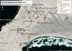
Vulnerability in the area of the "Machería" before the union of the beaches "Brava" and "Mansa" in the district of Lomas, Caravelí, Arequipa
DOI:
https://doi.org/10.15381/espiral.v4i8.26361Keywords:
Vulnerability, tsunami, land use planning, sea and housingAbstract
The purpose of this research work is to raise awareness of the high vulnerability to the possible union, as happened years ago, of the beach known as the "Brava" and "Mansa" in the area known as the “Machería” in the district of Lomas, Caravelí, Arequipa. Also make known the reason why they build their homes in an area of high vulnerability to an imminent tsunami since we are in the Pacific Ring of Fire and this makes there a greater vulnerability to an earthquake and its subsequent formation of the tsunami. We will include several aspects of Physical Geography, as well as the factors of vulnerability that can be seen in the study area.
Downloads
Published
Issue
Section
License
Copyright (c) 2022 Miguel Humberto Nuñez Saire, Karol Wendy Medina Luque

This work is licensed under a Creative Commons Attribution 4.0 International License.
LOS AUTORES RETIENEN SUS DERECHOS:
a. Los autores retienen sus derechos de marca y patente, y también sobre cualquier proceso o procedimiento descrito en el artículo.
b. Los autores retienen el derecho de compartir, copiar, distribuir, ejecutar y comunicar públicamente el artículo publicado en la revista Espiral (por ejemplo, colocarlo en un repositorio institucional o publicarlo en un libro), con un reconocimiento de su publicación inicial en la revista Espiral.
c. Los autores retienen el derecho a hacer una posterior publicación de su trabajo, de utilizar el artículo o cualquier parte de aquel (por ejemplo: una compilación de sus trabajos, notas para conferencias, tesis, o para un libro), siempre que indiquen la fuente de publicación (autores del trabajo, revista, volumen, número y fecha).


